Python Scripts
Note
Since Tiled 1.3, Tiled can be extended using JavaScript. The JavaScript API provides a lot more opportunity for extending Tiled’s functionality than just adding custom map formats. It is fully documented and works out of the box on all platforms. It recommended over the Python plugin whenever possible.
Tiled ships with a plugin that enables you to use Python 3 to add support for custom map and tileset formats.
For the scripts to get loaded, they should be placed in ~/.tiled.
Tiled watches this directory for changes, so there is no need to restart
Tiled after adding or changing scripts (though the directory needs to
exist when you start Tiled).
There are several example scripts available in the repository.
Note
To create the ~/.tiled folder on Windows, open command prompt
(cmd.exe), which should start in your home folder by default, then
type mkdir .tiled to create the folder.
On Linux, folders starting with a dot are hidden by default. In most file
managers you can toggle showing of hidden files using Ctrl+H.
Note
Since Tiled 1.2.4, the Python plugin is disabled by default, because depending on which Python version is installed on the system the loading of this plugin may cause a crash (#2091). To use the Python plugin, first enable it in the Preferences.
Warning
For the Tiled Python plugin to work you’ll need to install a compatible version of Python.
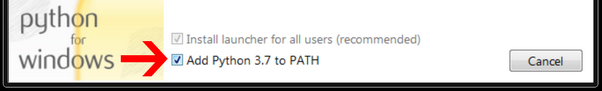
On Windows, get Python from https://www.python.org/. As of Tiled 1.11, the Windows 10+ build requires Python 3.12 whereas the Windows 7-8 build requires Python 3.8. You will also need to check the box “Add python.exe to PATH” in the installer:
On Linux you will need to install the appropriate package. However,
currently Linux AppImage builds are done on Ubuntu 22.04 against Python
3.10, and you’d need to install the same version (on Ubuntu likely
libpython3.10 and on Fedora python3.10-libs).
The Python plugin is not available for macOS releases, nor in the Ubuntu snap.
Example Export Plugin
Suppose you’d like to have a map exported in the following format:
29,29,29,29,29,29,32,-1,34,29,29,29,29,29,29,
29,29,29,29,29,29,32,-1,34,29,29,29,29,29,29,
29,29,29,29,29,29,32,-1,34,29,29,29,29,29,29,
29,29,29,29,29,29,32,-1,34,29,29,29,29,29,29,
25,25,25,25,25,25,44,-1,34,29,29,29,29,29,29,
-1,-1,-1,-1,-1,-1,-1,-1,34,29,29,29,29,29,29,
41,41,41,41,41,41,41,41,42,29,29,24,25,25,25,
29,29,29,29,29,29,29,29,29,29,29,32,-1,-1,-1,
29,29,29,29,29,29,39,29,29,29,29,32,-1,35,41,
29,29,29,29,29,29,29,29,29,29,29,32,-1,34,29,
29,29,29,29,29,29,29,29,37,29,29,32,-1,34,29;
You can achieve this by saving the following example.py script in
the scripts directory:
from tiled import *

class Example(Plugin):
    @classmethod
    def nameFilter(cls):
        return "Example files (*.example)"

    @classmethod
    def shortName(cls):
        return "example"

    @classmethod
    def write(cls, tileMap, fileName):
        with open(fileName, 'w') as fileHandle:
            for i in range(tileMap.layerCount()):
                if isTileLayerAt(tileMap, i):
                    tileLayer = tileLayerAt(tileMap, i)
                    for y in range(tileLayer.height()):
                        tiles = []
                        for x in range(tileLayer.width()):
                            if tileLayer.cellAt(x, y).tile() != None:
                                tiles.append(str(tileLayer.cellAt(x, y).tile().id()))
                            else:
                                tiles.append(str(-1))
                        line = ','.join(tiles)
                        if y == tileLayer.height() - 1:
                            line += ';'
                        else:
                            line += ','
                        print(line, file=fileHandle)


        return True
Then you should see an “Example files” entry in the type dropdown when going to File > Export, which allows you to export the map using the above script.
Note
This example does not support the use of group layers.
Tileset Plugins
To write tileset plugins, extend your class from tiled.TilesetPlugin
instead of tiled.Plugin.
Debugging Your Script
Any errors that happen while parsing or running the script are printed to the Console, which can be enabled in View > Views and Toolbars > Console.
API Reference
It would be nice to have the full API reference documented here, but for now please check out the source file for available classes and methods.
Note
Any help with maintaining the Python plugin would be very appreciated. See open issues related to Python support